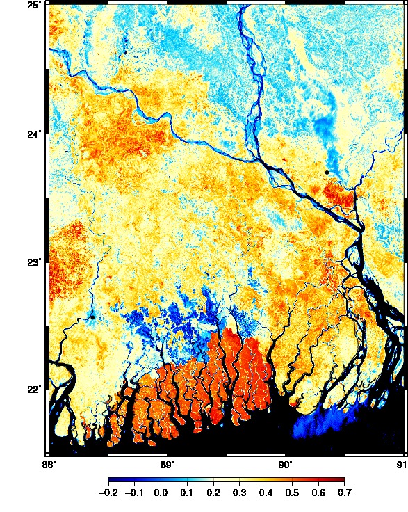
Feb.-14, 2011 MODIS Image of Ganges and Brahamaputra River Delta (250-m resolution),
Bangladesh: The country most likely impacted by changing sea level and changing water use by growing populations and rapidly growing new economies in India to the west and China to the east. Black is ocean and river water of the Ganges/Brahamaputra River Delta. The red in the south is the Sundabarns mangrove forest, and the blue are water-logged polders created by ill-advised water management measures planed in the 60ies and implemented in the 80ies and 90ies.
- Primary Sources:
- .pdf Development of Eco-efficient water infrastructures in Bangladesh by Fazlur Rashid, Dec.-2010
- .pdf of Review of River management Southwest Coastal Bangladesh by S. Islam and Z. Kibria, April-2006
- Media Links:
- bdnews24: "Tidal river plan could allay climate threat in southwest," Sept.-2009
- NY Times: In silt, Bangladesh sees potential shield against sea level rise, Mar.-2009
- Bangladesh Summaries on Community Based River Management in Southwest Bangladesh
- Wall Street Journal: "Global Warming as seen from Bangladesh," Nov.-2009
- Institutions:
- Bangladesh Center for Advanced Studies
- Grameen Bank (Micro-Credit)
- InternationRivers.org
- Information Technology for Humanitarian Assistance, Cooperation, and Action (Italian Spy Satellites)