Updated every sunday night.
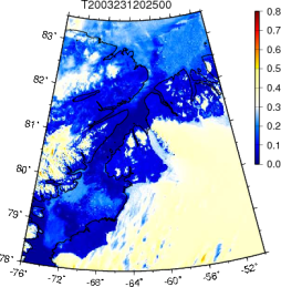
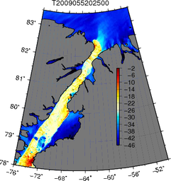
Graphical Table Petermann Glacier | Visible | Thermal
| Imagery: | Visible (645nm @ 250-m): | Thermal (11um @ 1-km): |
|
2016: Visible | Thermal 2015: Visible | Thermal 2014: Visible | Thermal 2013: Visible | Thermal 2012: Visible | Thermal 2011: Visible | Thermal 2010: Visible | Thermal 2009: Visible | Thermal 2008: Visible | Thermal 2007: Visible | Thermal 2006: Visible | Thermal 2005: Visible | Thermal 2004: Visible | Thermal 2003: Visible | Thermal 2002: Visible | Thermal 2001: Visible | Thermal 2000: Visible | Thermal |
| 
|
- Projects:
- Petermann Glacier 2000-12: Spring Gradients (Edge Detection)
- Kane Basin 2012: May-2 - present Ice Bridge Collapse
- Petermann Fjord 2010: Aug.-5 through Sept.-26 Ice Island Formation
- Lincoln Sea 2009: June-25 through Aug.-19 Ice Arch Collapse
- Kennedy Channel 2008/09: Winter Thermal Imagery with Cloud Masking (code)
- First trials 2009:
- Hans Island Weather Station: Scottish Marine Institute
MAST-867: MODIS Remote Sensing (Spring-2010 Class)
Processing (Outline): NASA Level-0 to UDel Level-1B web-posted graphics
1. wget -r -nd -l1 --no-check-certificate http://oceandata.sci.gsfc.nasa.gov/cgi/getfile/$name.L0_LAC.bz2
2. modis_L1A.csh $name.L0_LAC -o $name.L1A_LAC
3. modis_GEO.csh $name.L1A_LAC -b
4. modis_L1B.csh $name.L1A_LAC $name.GEO -b
5. seadas -em -b test.cmd
6. hdp dumpsds -n SolarZenith -o solz -b $device$dir/GEO/$name.GEO
7. hdp dumpsds -n EV_1KM_Emissive -o dump -b $device$dir/L1B/$name.L1B_LAC
8. hdp dumpsds -n EV_500_RefSB -o dump -b $device$dir/L1B/$name.L1B_HKM
9. hdp dumpsds -n EV_250_RefSB -o dump -b $devicedir/L1B/$name.L1B_QKM
10. hdp dumpsds -h -o tem0 $device$dir/L1B/$name.L1B_QKM
11. nawk -f check250.awk var=EV_250_RefSB name=$name ReflOffSet=12 tem0 >log.dat
12. g95 getbin2.f95
13. ./a.out $idev $iarea $out
14. ./kennedy.g $name
15. ./all-html.csh
Tue Nov 9 09:45:28 EST 2021